
Discovering the Power of Thermal Imaging Drones
Thermal imaging drones have emerged as one of the most transformative tools in modern aerial technology, allowing users to see beyond what the human eye or standard cameras can detect. These advanced systems capture invisible heat patterns from objects, people, and environments, delivering critical insights that were once only possible through ground-based efforts or expensive manned flights. Professionals across industries now rely on thermal imaging drones to gather data quickly and safely from the sky, turning complex challenges into manageable tasks. Whether exploring remote areas or monitoring large facilities, this innovation continues to reshape how we approach problem-solving in the field.
The rise of accessible drone platforms has made thermal imaging technology available to beginners and experts alike, without requiring years of specialized training. Compact yet powerful, these devices integrate seamlessly with user-friendly apps that display real-time visuals on a smartphone or tablet. As costs have dropped significantly in recent years, more enthusiasts and small businesses are discovering their potential, leading to widespread adoption worldwide. This accessibility ensures that even those new to the concept can start exploring its capabilities with confidence and minimal investment.
How Thermal Imaging Technology Works in Drones
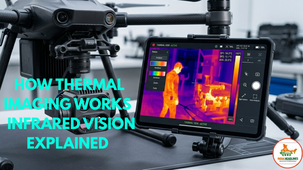
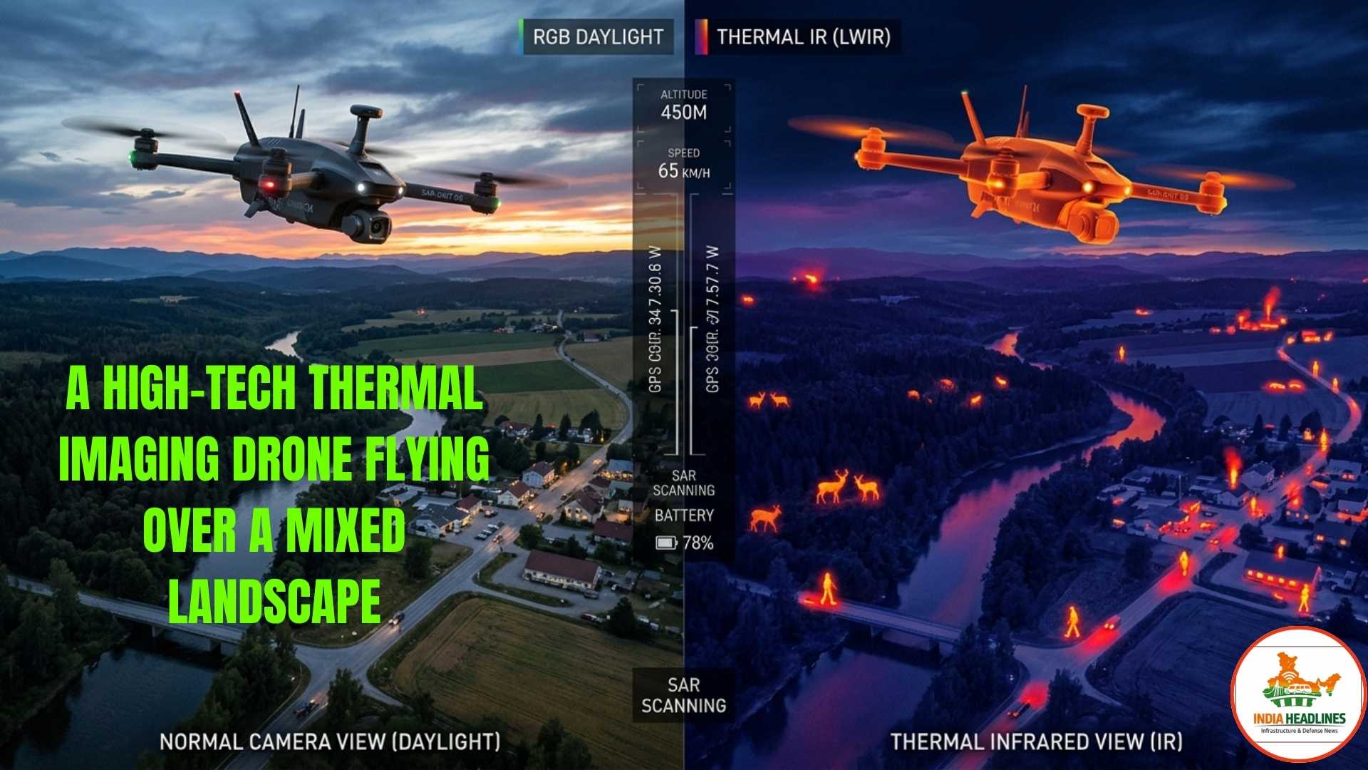
At its core, thermal imaging relies on detecting infrared radiation naturally emitted by all objects based on their temperature, creating detailed maps of heat variations that standard photography simply cannot reveal. Specialized sensors known as microbolometers inside the camera convert these invisible waves into visible color-coded images, where warmer areas might appear in bright reds and cooler spots in deep blues. Mounted on lightweight drones, this setup provides a stable aerial perspective that covers vast areas efficiently, far surpassing handheld thermal devices in scope and speed. Operators can fly at safe distances while still capturing precise temperature data, making it an invaluable asset for time-sensitive operations.
The integration of advanced image processors further enhances clarity by filtering out noise and adjusting for environmental factors like wind or humidity. Unlike visible-light cameras that struggle in darkness or fog, thermal imaging drones perform exceptionally well regardless of lighting conditions, offering consistent performance day or night. Beginners often appreciate the intuitive color palettes that translate complex data into easy-to-read visuals, helping them interpret results without advanced technical knowledge. This reliable technology ensures trustworthy outcomes that professionals can depend on for critical decision-making.
🚁 Thermal Imaging Drones
Revolutionary Aerial Technology Analysis
Comprehensive overview of cutting-edge infrared drone technology, applications across industries, and the future of aerial thermal detection systems
Technical Specifications & Feature Matrix
Detailed breakdown of thermal imaging drone capabilities and real-world applications
| No. | Key Component | Features & Specifications |
|---|---|---|
| 1 | Core Technology | Infrared radiation detection through microbolometers, converts heat patterns to color-coded images (warm=red, cool=blue) |
| 2 | Performance Capability | Works day or night, penetrates smoke and fog, provides stable aerial perspective over vast areas |
| 3 | Search & Rescue Application | Locates trapped individuals by detecting body heat signatures through rubble, smoke, or dense forests |
| 4 | Firefighting Use | Identifies hidden hotspots in burning buildings for safer containment strategies |
| 5 | Industrial Inspection | Examines power lines, pipelines, solar farms for overheating components and energy leaks from above |
| 6 | Agricultural Monitoring | Detects crop stress and irrigation issues through temperature differences indicating health problems |
| 7 | Safety Enhancement | Non-invasive approach keeps operators at safe distance from hazardous environments like fire zones |
| 8 | Cost Efficiency | Faster surveys than manual inspections, early detection prevents expensive repairs, reduces downtime |
| 9 | User Accessibility | User-friendly apps with automated flight modes, suitable for beginners with minimal training required |
| 10 | Data Quality | Highly repeatable and shareable results, advanced processors filter noise for clear, reliable documentation |
Top Applications Across Various Sectors
From emergency response teams to agricultural experts, thermal imaging drones are proving essential in diverse fields by providing unique aerial heat detection that saves lives and resources daily. In search and rescue missions, they quickly locate individuals trapped in rubble or lost in dense forests by spotting body heat signatures even through smoke or foliage. Firefighters use them to identify hidden hotspots in burning buildings, allowing safer and more effective containment strategies without unnecessary risks to personnel. Wildlife conservationists also benefit greatly, tracking animal movements in protected areas without disturbing natural habitats.
Industrial inspections represent another major area where these drones excel, helping engineers examine power lines, pipelines, and solar farms for faults that traditional methods might miss. By revealing overheating components or energy leaks from above, they prevent costly breakdowns and reduce downtime significantly. In agriculture, farmers monitor crop health and irrigation efficiency by detecting temperature differences that signal stress or disease early on. These practical uses demonstrate how thermal imaging technology delivers measurable value across sectors, proving its versatility in real-world scenarios.
Unveiling the Key Benefits of Using These Drones
One of the standout advantages of thermal imaging drones lies in their ability to enhance safety by keeping operators at a secure distance from hazardous environments like active fire zones or high-voltage structures. This non-invasive approach minimizes human exposure to danger while still providing comprehensive data collection, a feature that has earned trust from safety regulators globally. Additionally, the speed of aerial surveys means large areas can be covered in a fraction of the time compared to manual inspections, leading to faster responses and lower operational costs overall. Users consistently report improved accuracy and efficiency once they integrate these tools into their workflows.
Cost savings extend beyond labor, as early detection of issues through precise heat signatures prevents minor problems from escalating into expensive repairs or failures. The data collected is also highly repeatable and shareable, supporting better documentation and compliance with industry standards. For beginners, the user-friendly interfaces and automated flight modes reduce the learning curve dramatically, empowering more people to harness this powerful technology. Overall, the combination of reliability and affordability positions thermal imaging drones as a smart investment for forward-thinking organizations and individuals alike.
Practical Advice for Beginners Entering the Field
Starting with thermal imaging drones requires understanding basic flight regulations and selecting equipment suited to your specific needs, whether for hobbyist exploration or professional projects. Focus on models with intuitive controls and built-in thermal cameras that offer clear resolution without overwhelming complexity, and always practice in open areas to build confidence before tackling real missions. Familiarize yourself with software features for analyzing captured images, as proper interpretation turns raw data into actionable insights that drive results. Taking online courses or joining local drone communities can accelerate your progress while connecting you with experienced users.
Battery life and weather conditions play crucial roles in successful flights, so beginners should plan missions during calm periods and carry spare power sources to avoid interruptions. Regular maintenance of the drone and camera ensures optimal performance and longevity, building a foundation of reliability for future operations. By prioritizing safety checklists and gradual skill-building, newcomers can avoid common pitfalls and maximize the potential of their thermal imaging setup from day one. This methodical approach fosters expertise over time, transforming initial curiosity into professional-level proficiency.
Conclusion
Thermal imaging drones represent a remarkable fusion of cutting-edge infrared technology and aerial innovation, delivering unmatched capabilities that enhance safety, efficiency, and discovery across countless applications. By revealing hidden heat signatures invisible to the naked eye, they empower users to make informed decisions that protect lives, preserve resources, and drive progress in ways traditional tools never could. As this technology continues evolving, it invites everyone—from curious beginners to seasoned professionals—to rethink how we observe and interact with the world around us. The question remains: how will you harness these powerful insights to create meaningful impact in your own field?
Read More
UP becomes global investment hub: 55% expressway network transforms development landscape in 9 years